The group will split in South Africa.
The PC12 will fly eastward to California via a southern Pacific Route with stops in Australia, Tasmania, New Zealand, Tonga, Fiji, Tahiti, Easter Island and then Chili, Peru and Central America.
Stuart Auerbach and I will be flying the Mustang back to the US to be on time for the TBMOPA Convention in Coeur d'Alene.

The return is set from CapeTown on September 20th and the plan is to be in Coeur d'Alene on the evening of the 25.
Here is the map to my former hometown Lille
Here are the distance
| From | To | Initial Heading | Distance | |||||
|---|---|---|---|---|---|---|---|---|
| 9 segment path: | 5800 nm | |||||||
| FACT (33°58'17"S 18°36'15"E) | FBMN (19°58'21"S 23°25'52"E) | 18.3° | (N) | 876 nm | ||||
| FBMN (19°58'21"S 23°25'52"E) | FLLS (15°19'51"S 28°27'09"E) | 46.8° | (NE) | 400 nm | ||||
| FLLS (15°19'51"S 28°27'09"E) | HUEN (0°02'33"N 32°26'37"E) | 14.8° | (N) | 948 nm | ||||
| HUEN (0°02'33"N 32°26'37"E) | HSSS (15°35'22"N 32°33'11"E) | 0.4° | (N) | 928 nm | ||||
| HSSS (15°35'22"N 32°33'11"E) | HEBL (22°22'33"N 31°36'42"E) | 352.6° | (N) | 409 nm | ||||
| HEBL (22°22'33"N 31°36'42"E) | HESN (23°57'52"N 32°49'12"E) | 34.9° | (NE) | 116 nm | ||||
| HESN (23°57'52"N 32°49'12"E) | LGSR (36°23'57"N 25°28'46"E) | 334.6° | (NW) | 836 nm | ||||
| LGSR (36°23'57"N 25°28'46"E) | LDZD (44°06'30"N 15°20'48"E) | 318.0° | (NW) | 655 nm | ||||
| LDZD (44°06'30"N 15°20'48"E) | LFQQ (50°33'48"N 3°05'13"E) | 312.2° | (NW) | 631 nm | ||||
| Total: | 5800 nm | |||||||
at a 300kts cruise speed in a no wind condition it should take about 20 hours of flying time.
Then from Lille to Coeur d'Alene:
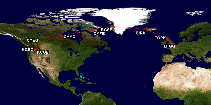
| From | To | Initial Heading | Distance | |||||
|---|---|---|---|---|---|---|---|---|
| 8 segment path: | 4284 nm | |||||||
| LFQQ (50°33'48"N 3°05'13"E) | EGPK (55°30'34"N 4°35'12"W) | 319.9° | (NW) | 406 nm | ||||
| EGPK (55°30'34"N 4°35'12"W) | BIRK (64°07'48"N 21°56'26"W) | 321.9° | (NW) | 734 nm | ||||
| BIRK (64°07'48"N 21°56'26"W) | BGSF (67°01'01"N 50°41'22"W) | 296.5° | (NW) | 730 nm | ||||
| BGSF (67°01'01"N 50°41'22"W) | CYFB (63°45'23"N 68°33'21"W) | 254.7° | (W) | 487 nm | ||||
| CYFB (63°45'23"N 68°33'21"W) | CYYQ (58°44'21"N 94°03'54"W) | 259.4° | (W) | 792 nm | ||||
| CYYQ (58°44'21"N 94°03'54"W) | CYEG (53°18'35"N 113°34'47"W) | 251.9° | (W) | 730 nm | ||||
| CYEG (53°18'35"N 113°34'47"W) | KGEG (47°37'09"N 117°32'07"W) | 205.5° | (SW) | 374 nm | ||||
| KGEG (47°37'09"N 117°32'07"W) | KCOE (47°46'28"N 116°49'10"W) | 71.9° | (E) | 30 nm | ||||
| Total: | 4284 nm | |||||||
This would be an additional 15 hours of flying in no winds
No comments:
Post a Comment